It's been 8 months since cyclone Gabrielle rearranged our province. And if you move in certain circles you could probably let yourself forget that there is still such a mess out there. In some respects, it's not until you drive out into the land that you become reacquainted with just what happened and how far we still have to go to put things back in order- to repair lives, homes and restore the land.
We've stayed away from the most devastated areas out of respect and had no reason to travel State Highway 2 until now, but then we decided that October would be an ideal time to walk to Bell Rock especially as Rob had Labour day off, the weather was settled, not too hot, nor too windy and no rain either. From home we calculated that it should take us an hour and a half to get there. Instead it took us two.

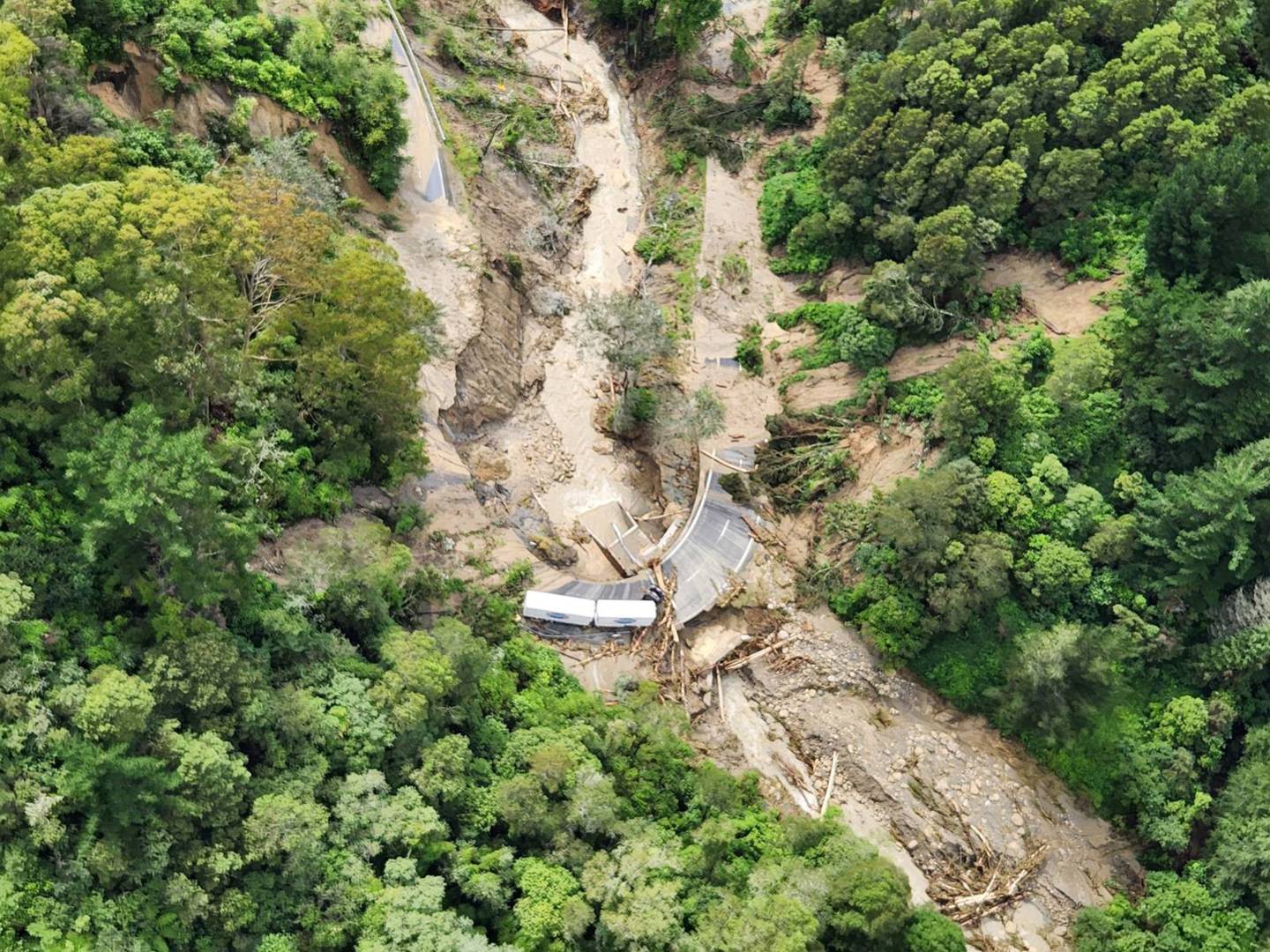
But considering that on the 15th February 2023 the state of this road was what you see below it's nothing short of a miracle that it's open at all. Photo NZDF
'Devil's Elbow'
Time stands still.


Since I'm not great on practical details I am borrowing Vivienne Haldane's directions on how to get there:
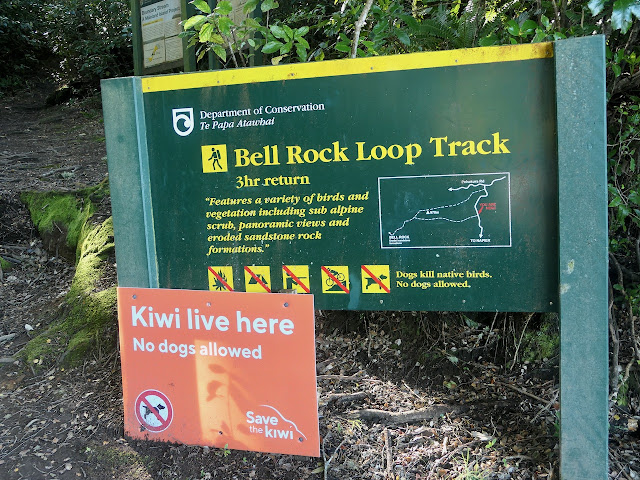
"To reach the start of the track, turn left at the store into Matahorua Road for 4kms, then turn left at the fork into Pohokura Road for another 12kms. Bell Rock is part of the Boundary Stream Mainland Reserve and is just one of several walks here; others include Tumanako Track, Kamahi Loop Track, Bell Bird Bush, and Shine Falls. We stopped at the car park, where signs in a well-built shelter had loads of information about the trails. Rather than walk from here, we decided to park a little further up the road (1.5kms) at a layby. "
You can read her informative article just here.
.jpeg)
The 12 kms of unsealed road is ok, just slow. But that's good- you get a chance to chill and observe and hope that no one wants to get passed coming the other way!
We hadn't realised the significance of the 'Boundary Stream Mainland Island'


And this is quite useful too- the Land Safety Code helpful for good planning.

There's a huge preponderance of mature Beech and Rewarewa trees right from the start.
 Beech trees are so graceful.
.jpeg) Our pace was slow and measured as we had to keep our eyes on the ground, but at the same time wanted to look up and see everything!
Our pace was slow and measured as we had to keep our eyes on the ground, but at the same time wanted to look up and see everything!
.jpeg)
 It was fascinating to notice the abundance of Horopito
It was fascinating to notice the abundance of Horopito
 and native tree fuchsia in the understory.
 The fuchsia flowers are tiny- more easily seen as they fall to the forest floor.
.jpeg)
.jpeg)
 "Really! So what are we when we're at home?"
"Really! So what are we when we're at home?"

.jpeg)
.jpeg)
Like this succulent juvenile Angiangi lichen.
.jpeg)


.jpeg)
It's the trunks of these trees that are most remarkable.
.jpeg)
I suddenly tuned in to realise that I had never heard this particular bird song before. It turned out that we were hearing a native Tomtit (Miromiro). You can see and hear this little darling just here.
About now Rob said "Oh look we're at 1000 metres above sea level.".jpeg)
11 metres- I was informed.
There's been a few conversations lately about the knowledge of plants, especially when wild crafting or foraging and how there's so much that most of us don't know. There are not many truly dangerous plants in our landscape, but those that are a potential threat are important to know well.
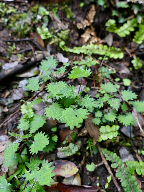
Like this innocent little seedling on the forest floor called Ongaonga- a native tree nettle that packs a powerful sting, one that would surely ruin the walk if you walked on it in bare feet or thought you'd pick a little for soup. Should you fall in to a mature Ongaonga bush you may even die- painfully.
 "Beneath the forest canopy lies a seamless living carpet of mosses, lichens and liverworts. These simple plants not only clothe the forest floor, they grow `wall-to‑ wall’, adorning tree trunks, rocks and even rivers and pools with a spectacular array of colours, shapes and textures." NZ Geographic

And isn't this a fascinating word- 'totipotent'! 'Mosses and liverworts are said to be totipotent, meaning that literally any part that has broken off can grow into a new plant.'
This lichen appears to be Lobaria pulmonaria and how fascinating are it's other names!
"Lobaria pulmonaria has many common names including tree lungwort, lung lichen, lung moss, lungwort lichen, oak lungs or oak lungwort. The use of "lung" reflects the fact that it looks somewhat like human lung tissue but also connects to the sensitivity of this species to air pollution. Lobaria pulmonaria populations around the world have been declining as a result of human activities and in Estonia the population is estimated to have been reduced by around 90% since the late 19th century."
Info from here.
.jpeg)
.jpeg)
.jpeg)


Even some lovely Rimu trees- most unusual to see in Hawke's Bay.

It took us almost an hour to move through the forest (so much to see), but eventually we emerged in to a completely different landscape.
.jpeg)

.jpeg)
.jpeg)


.jpeg)
And then we found some Mountain Holly.

.jpeg)


.jpeg)
Spring is pretty unpredictable so it was amazing that the weather was so settled for this one day when lots of us were able to make the journey.
.jpeg)
These siblings below were just magic to watch- fearless.
.jpeg) But sesnible.
But sesnible.
 The light was a bit strange, the valley below and vistas beyond washed in a perpetual haze, but windless was just perfect!

.jpeg)
.jpeg)
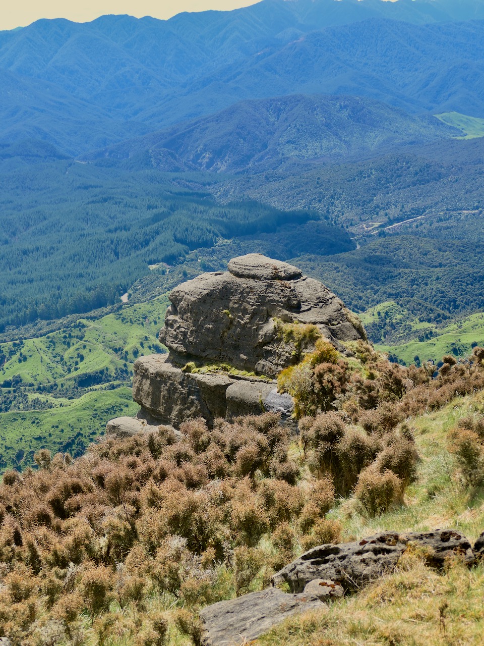
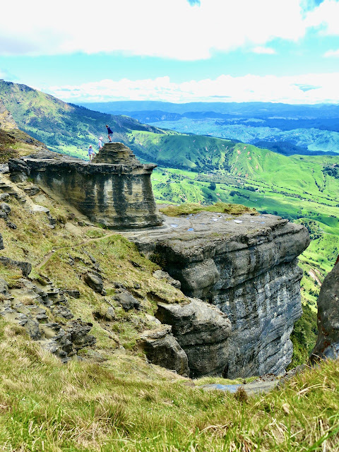 "The rock formations almost look alien, and it's breathtaking to think they were once part of the seafloor and are made up of sediment and seashells.
.jpeg)


.jpeg)
.jpeg)

Over millions of years, the seafloor compacted, and after some dramatic geological uplift, now sits hundreds of metres above today’s sea level.The area has also been impacted by New Zealand's vast volcanic history including the Taupō eruption of 1800 years ago. The Department of Conservation (DOC) explains the eruption caused "a sheet of hot pumice and volcanic gases that flowed over the land at hundreds of kilometres per hour." Despite being more than 70 kilometres from Taupō’s crater, as the crow flies, the outer edge of flow reached what’s in front of us."

.jpeg)


.jpeg)
 And when I looked down I saw the sea floor!
And when I looked down I saw the sea floor!
 On this flat bit, right near the edge I spotted these familiar bright yellow signs of resilience and thrival. Dandlions!
.jpeg) More native daphne.
More native daphne.
.jpeg) When I was about 10 my father must have been working on the Havelock North ski lodge up Mount Ruapehu as we were up there one weekend in summer as a family. I hated the cold and the snow, but I loved this trip 'cos there were amazing flowers and I was entranced. I recall mountain daisies like this one below.
When I was about 10 my father must have been working on the Havelock North ski lodge up Mount Ruapehu as we were up there one weekend in summer as a family. I hated the cold and the snow, but I loved this trip 'cos there were amazing flowers and I was entranced. I recall mountain daisies like this one below.
 I honestly wouldn't want to take small children up to Bell Rock. There is so much that could go wrong. We were holding our breath when a number of adolescent boys insisted on going right to the edge and shouting in to the void and refusing to move back. All parental instruction was ignored!
 A curious, cautious ease and poise felt much safer.
.jpeg)
.jpeg)

I've borrowed that bit from Brook Sabin's article about Bell Rock here.


.jpeg)


At about this point we became aware of a young woman sitting on the rock behind us.
Self assured and fully in the moment we hoped we weren't disturbing her down here.
And then we heard a drone, What, yes a drone. Clang!
I made large biscuits to take on our journey.
These are great- loads of oats & even grated apple. The recipe is just here.
.jpeg)
Above us sat the crown of the rock.
.jpeg)


.jpeg)
.jpeg)


.jpeg)
This man was well behaved- phew.
.jpeg)
.jpeg)
.jpeg)
Native daphne blooming to the edge!

A trio of ancient, native Tree fuchsias.
Oh how I loved this tree. It feels like a genuine Kiwi Christmas tree. Adorned with Usnea (Angiangi). Every Christmas tree should be made of medicine.
On our decent this Horopito caught my eye- what rich medicine it holds within.
About now Rob was feeling a bit tender with one knee and I was noticing mine. I immediately recalled that Horopito is known as The Bushman's Pain Killer. If needs be we could have nibbled on these wonderfully vibrant leaves to ease our way. We could also have paused and worked our Stomach 36 points- known in Chinese medicine circles as Three Mile Point.
"This is one of the most famous and commonly used acupuncture (acupressure) points. The name of this point reflects its use for accessing deep nourishment and energy when we are worn out and fatigued. “Just 3 more miles. I can make it!"
And back down we go.
When we got home I found him- a Pitpit, Pihoihoi
You can see and hear this wee bird just here.
How cool is that! An 'uncommon' native bird.
.jpeg) It was about this point that I kept seeing the young woman that we'd noticed on the top of the rock, engaged with the majesty of the moment. And then it occurred to me that I may have taken a photo or two of her, but she was quick footed and I never quite caught up with her until...we arrived at the descending juncture where could choose to go back through the forest or, we could head down the ridge and complete the loop. That's when I called out to Maya and we started chatting. And she told us she was worried that we might have thought that it was her drone. Dratted teenage boys!
It was about this point that I kept seeing the young woman that we'd noticed on the top of the rock, engaged with the majesty of the moment. And then it occurred to me that I may have taken a photo or two of her, but she was quick footed and I never quite caught up with her until...we arrived at the descending juncture where could choose to go back through the forest or, we could head down the ridge and complete the loop. That's when I called out to Maya and we started chatting. And she told us she was worried that we might have thought that it was her drone. Dratted teenage boys!
.jpeg) As we walked down the steep descent we quickly connected and discovered that Maya was a delightful and courageous young Czech/Vietnamese woman travelling and working alone. As we walked together we heard a bird call that was familiar to us- suddenly we realised that we were hearing a male Kiwi call. Then we came upon this sacred site.
As we walked down the steep descent we quickly connected and discovered that Maya was a delightful and courageous young Czech/Vietnamese woman travelling and working alone. As we walked together we heard a bird call that was familiar to us- suddenly we realised that we were hearing a male Kiwi call. Then we came upon this sacred site.
 Once again I am borrowing Vivienne Haldane's knowledge: "Maungaharuru is the spiritual home of the hapu, Ngāti Kurumōkihi. They are the kaitiaki (guardians) of Boundary Stream and nearby reserves. In 2017, as part of a Treaty settlement to redress grievances from 150 years ago, four DOC reserves in northern Hawke’s Bay were returned to their original owners, hapu (including Ngāti Ngāti Kurumōkihi), represented by the Maungaharuru-Tangitu Trust. Shortly after this, the hapū generously gifted back the four reserves to the people of Aotearoa."
 I had had enough by now and my legs were shouting "don't be lost!" But the other two kept looking at their phones and saying we were fine.
 Impressive grove of gum trees.
 It was about now I was both awed and whiny. "Look at that! Are you sure we're not lost?"
 And then quite abruptly we came to a gate, that we had to climb over and then take a right turn and wander back down the road. For the navigationally challenged this was all a bit much 'cos I just knew that I could not walk back up that hill if we'd taken a wrong turn, Kiwi call or not!
And then...I stopped mid- stride arrested by a flower I had never seen in my life before.
 Apparently this is a Mountain Foxglove
.jpeg) Ourisia macrophylla
Ourisia macrophylla
 So exciting!!!
.jpeg) And then there were Bluebells- long finished at home.
And then there were Bluebells- long finished at home.
 Next thing- Maya spotted her van. She's been living out of it for a year as she works and travels.
.jpeg) We said our goodbyes but as the van came offered sustenance in the way of spare huge biscuits through the van window, a shower and a bed for night in Lucy- our vintage caravan, back in Hastings. Maya said she'd be in touch as she headed off to reach Te Mata Peak before the sunset.
We said our goodbyes but as the van came offered sustenance in the way of spare huge biscuits through the van window, a shower and a bed for night in Lucy- our vintage caravan, back in Hastings. Maya said she'd be in touch as she headed off to reach Te Mata Peak before the sunset.
 Our return journey was so much quicker- down hill all the way!
The walk itself though is hard. Let's be honest. I've heard people say that 'everyone' should come here, but that's just not realistic. I would not call it an easy or even moderate walk. An 8 km 3 hour walk sounds fine, but then there's the context of this particular terrain and there is very little that is flat in this trail. We are so glad that we have managed, but we wouldn't go again tomorrow.
We were amazed, on our way home, to see how little the land has healed since the cyclone in mid February.
 I started making pasta with roasted asparagus and smoked salmon (from the Farmer's Market) when we arrived home. Soon enough Maya checked in to tell us she was on her way.
And she stayed- in Lucy our little vintage caravan. And we had the most heartfelt and wonderful time together.
 Our shared motto" "Live for joy".
We surely will.
❤️.jpg)
.jpg)
.jpeg)


No comments:
Post a Comment